Map overlay "plug-in" for Google Earth
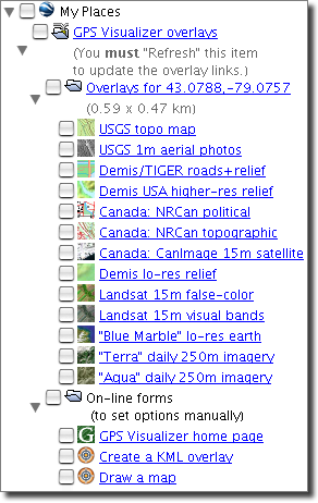
This is a KML Network Link (which acts somewhat like a plugin or extension) that allows you to view various alternate background overlays (click here for examples) in Google Earth; the graphic on the right shows which types of maps are available. Please read the following for more information about how it works:
- The special Garmin Custom Maps version of the overlay link will help automate the process of creating maps that can be loaded into the Garmin Colorado, Oregon, and Dakota series of GPS devices. You can read more about this feature on Garmin's blog, or see GPSFix.net for specific instructions on creating custom maps using GPS Visualizer. NOTE: When using the Garmin links, or ANY "static" overlays, you MUST set Google Earth to "Show web results in external browser."
- When you navigate to a new position, you must refresh the GPS Visualizer network link (its icon looks like a folder with wires coming out of it) by right-clicking and selecting "Refresh" from the contextual menu. If you don't refresh before clicking on a link, you will generate an overlay for the location you were viewing when the link first loaded, or when you last refreshed. (This is by design.)
- I highly recommend that you only refresh the network link when you're looking straight down. If your current view includes the horizon, your generated overlay will stretch all the way to the horizon, and the resolution will suffer accordingly.
- You will not always see all the options; the link tries to be "smart" about where you are in the world. For example, it won't give you an option for NRCanada maps when you're in Europe, and it won't give you USGS topo maps if you're in northern Canada.
- The overlay generator takes note of how large an area you're viewing. You won't get a link to 1m aerial photos if you're looking at a 100km area where they wouldn't really help. (This is related to the importance of looking straight down; if the view angle is too low and a lot of the surrounding area is visible, your choices will be limited.)
- If the area you're viewing is smaller than the area that could be covered at full resolution by the given map type, it goes ahead and creates a larger overlay anyway. For example: if you are looking at a 4km area, and you select "USGS topo," it will draw an overlay covering 6km because the maximum size for that map type is 2000px, and the maximum resolution is about 3 m/px.
- If you don't like any of this "trying to be smart" business -- for instance, if you want to see an aerial photo larger than 20km, or you don't want it to generate an full-res image larger than your view area -- you can click on the Create a KML overlay form link in the second folder; it will pre-fill the form with the current center point and height/width, but you're free to override any of the values and select any map type there.
- If it doesn't work -- specifically, if you get overlays but they look "corrupted" and staticky, or GE becomes unresponsive -- it might just be that your computer doesn't have the resources available to display large Google Earth image overlays. You might try using the overlay input form (via the "Create a KML Overlay" link in the plugin) and generating a smaller size, like 600 pixels instead of 2000.
| |
 |
(If all you need to do is convert your data into a KML/KMZ file, you probably want the Google Earth map input form.)
Return to the main GPS Visualizer page
|


![adam [at] gpsvisualizer [dot] com](/images/email-11.png) .
.