The problem: Sometimes you have geographic data that consists only of latitudes and longitudes, but you want to know the altitudes as well — because, for example, you want to colorize points by height above sea level, or draw a profile of a track. Here are some common reasons why you might have "flat" or incomplete data:
Your GPS device does not log altitude, or you had poor satellite reception when you recorded the track.
Your GPS device does log altitude, but it's not very accurate.
You drew a track using the drawing tools in Google Earth or a similar application, like GPS Visualizer's Sandbox.
You have a KML file that came from Google Maps or Google Earth's "driving directions" feature.
You created a route in Google Maps and have the URL of that route.
You have an NMEA log file that contains only "GPRMC" sentences, not "GPGGA."
Support GPS Visualizer
If you find the utilities on GPSVisualizer.com interesting, time-saving, or just plain fun, you can say "thanks" — and encourage further development — by clicking the button above and making a contribution via PayPal.
Solution #1: DEM database
GPS Visualizer's map, profile, and conversion programs have the ability to instantly add elevation data — from a DEM (digital elevation model) database — to any type of GPS file. If you just want to draw a profile, or convert a single data file to plain text or GPX while adding elevation, you can use the simple form right here:
Or, look in GPS Visualizer's various input forms for the menu called "Add DEM elevation data," and choose one of the elevation databases (described in the table below). Complete copies of the SRTM3 and USGS NED databases, as well as a large number of SRTM1 and ASTER tiles, are stored on GPS Visualizer's server — that's more than 250GB of raw data.
Note that the elevation-adding feature will erase any existing altitude data (for example, from a GPS) that might already be in your file. Often, this is desirable; profiles made with DEM data are usually "smoother" looking than GPS, and typically contain fewer gaps or suspicious readings. (Speaking of gaps, there are a few in NASA's SRTM data, and that's unavoidable. If GPS Visualizer runs into one of these, it will not overwrite those elevations in your input data.)
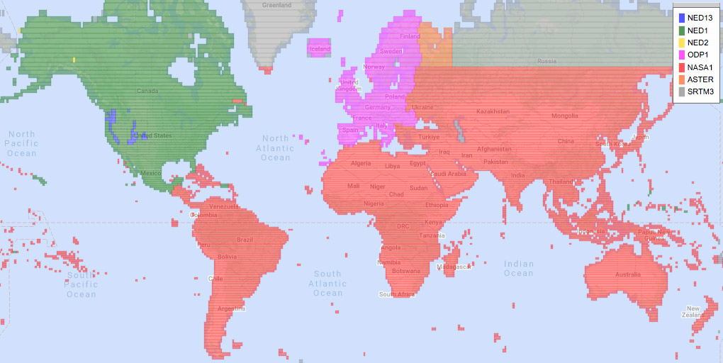
DEM data sources
NED (USGS)
The U.S. Geological Survey's excellent National Elevation Dataset covers the United States, Canada, and Mexico. 1 arc-second (~30-meter) horizontal resolution is available in most areas (NED1). For Alaska, 60-meter data is also available (NED2). USGS also produces 1/3-arc-second data (NED13), but because those files are nine times larger than NED1 files, only a few mountainous areas (Cascade Range, Sierra Nevada, southern Utah, etc.) are available on GPS Visualizer.
NASA1
NASA's SRTM1 data (from the Space Shuttle Radar Topography Mission) has a resolution of 1 arc-second (about 30 meters) and covers the entire world between 60°S and 60°N. Recently, they've re-processed and enhanced the SRTM1 data — using ASTER, NED, and GLAS, among other sources — to produce the "NASA DEM," which has replaced SRTM1 in GPS Visualizer.
ODP1
Digital 1-arcsecond terrain models of European countries, compiled and resampled by Sonny; formerly hosted by Austria's OpenDataPortal (hence the "ODP" code) and currently available at https://sonny.4lima.de/. These are high-quality digital elevation files from Western Europe and Iceland which have been copied to GPS Visualizer's server. Most of the files are a combination of SRTM1 and local LIDAR and/or survey data, and they have a horizontal resolution of 1 arc-second (about 30 meters north-south and 20 meters east-west). In most locations, they are more accurate than SRTM1 files.
ASTER
The ASTER GDEM is a joint product of NASA and the Japanese Ministry of Economy, Trade, and Industry (METI). ASTER has good 30-meter coverage of the entire world, but the massive size of the database makes it impractical to store all of it on GPSVisualizer.com. (As with SRTM1 data, additional files can be added upon request.)
SRTM3 (NASA)
NASA's SRTM3 v3 dataset includes 90-meter resolution for the entire world. SRTM3 data normally only goes up to about 60° latitude, but thanks to the efforts of the volunteers at Viewfinder Panoramas, GPS Visualizer has the polar regions covered as well.
"Best available"
GPS Visualizer will automatically select the best DEM data available in a given location. The quality ranking is as follows: NED13, NED1, ODP1, SRTM1, ASTER, NED2, ODP3, SRTM3. Click here for a map.
Solution #2: Google Maps API
The Google Maps API is able to return elevations for points anywhere in the world; these are often (but not always) the same elevations you'd see in Google Earth. Google's data comes from a variety of sources and is sometimes more accurate than the SRTM databases.
The drawback is that there is a limit on the number of queries that can be performed in a day by each user, so GPS Visualizer cannot ask Google for all of your points. To get around this, GPS Visualizer hosts a JavaScript-based Elevation Lookup Utility that has your browser perform the queries. To use this tool, your data must be in simple tabular format (easily accomplished using GPSV's plain-text converter); you must remove any existing elevation data; and you must have your own Google Maps API Key. Further instructions are on the Elevation Lookup Utility page.

![[Donate via PayPal]](/images/paypal-130x50.png)
![adam [at] gpsvisualizer [dot] com](/images/email.svg) .
.